Tree classification using drones?

the story so far 📚
The use of drones for remote sensing has become more widely accessible and available. For some, it's tempting for those outside the civil engineering and geospatial space to see aerial options as faster and cheaper options to on the ground surveys.
Where is the future?
While on the ground surveys are the gold standard, new and developing technologies will push their cost and time to the limits. One of the fastest developing areas is that of tree surveys. While each state differs on their requirements, often, an overview of the survey area is extremely valuable for determining time and cost of an on the ground tree survey. But there are those who are looking to use machine learning to help identify trees (both in type and location) from the air.
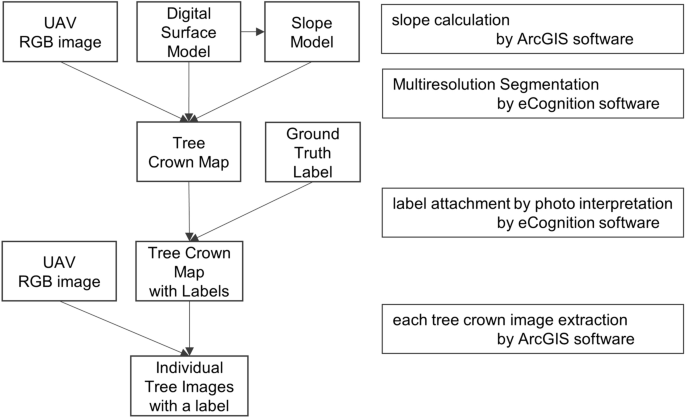
This paper by Onishi & Ise (2021), explores methods using machine learning and uav's to obtain more detailed tree data that can be used to identify trees more accurately.
Thus far, remote sensing research with these objectives has mainly employed satellites or aircraft. In the past, much attention has been devoted to multispectral Landsat satellites, which, because of their low cost, facilitate the mapping of forest types6. The advantage of Landsat satellite is that it enables the coverage of vast areas, i.e. on a country scale. However, its resolution is 30 m, which does not allow easy identification of tree species. Onishi & Ise (2021)
With a better way to collect data, researchers have sought to account for accuracy and finer detection models. The "holy grail" is to be able to obtain data for specific trees that can be used to determine tree health to assist with preservation.
future research directions should include species identification and evaluating the accuracy of estimating other tree-level characteristics such as DBH and crown area, which are important factors required for estimating biomass and stem volume. Mohan, et al. (2017)
It would appear to me, that the imaging technology and accessibly is only getting better as time goes on, but what still needs to be developed are the algorithms used to classify trees.
To increase digital classification accuracies with UAV-based multispectral remote sensing data, additional research is warranted in sensor data radiometric, spatial, and temporal characteristics, species-specific variable extraction (e.g., crown shape and structure), automated tree delineation, and more complex decision rule development. Franklin (2017)
Regardless of the methods, the sticking point now, seems to be finding algorithms that can identify trees in areas that are not so uniform. As machine learning can process larger datasets with more detail, hopefully patterns and relationships will emerge that will lead to better identification algorithms.


